


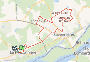
Possonnière Coulaines -coteaux Savennières

randoposso49
User

Length
11.1 km

Max alt
66 m

Uphill gradient
102 m
Km-Effort
12.5 km

Min alt
28 m

Downhill gradient
103 m
Boucle
Yes
Creation date :
2022-01-03 12:46:33.008
Updated on :
2022-01-04 09:39:18.074
3h17
Difficulty : Difficult

FREE GPS app for hiking
 SityTrail
IGN / Geographical institutes
SityTrail Plus
The world is yours!
About
Trail Walking of 11.1 km to be discovered at Pays de la Loire, Maine-et-Loire, La Possonnière. This trail is proposed by randoposso49.
Positioning
Country:
France
Region :
Pays de la Loire
Department/Province :
Maine-et-Loire
Municipality :
La Possonnière
Location:
Unknown
Start:(Dec)
Start:(UTM)
674499 ; 5249335 (30T) N.
Comments